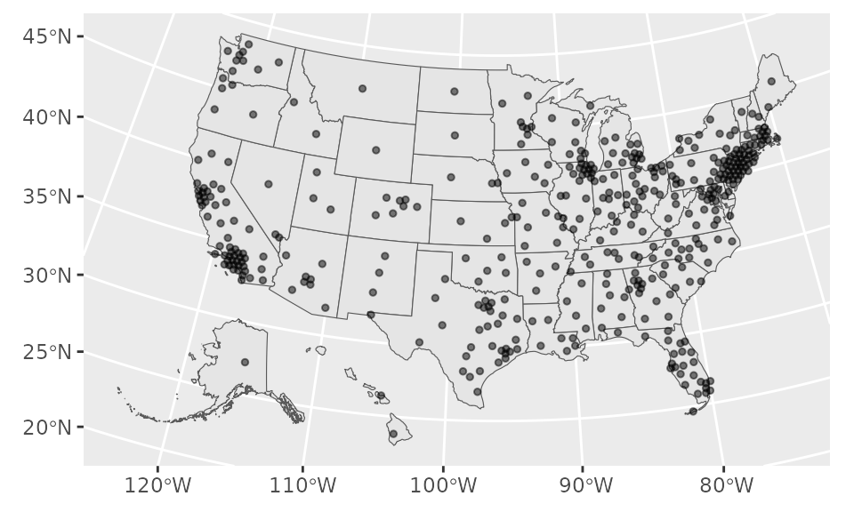
Loads shapefile of coordinates. Each row contains a coordinate of the centroid of the CD, slightly dodged so that points in dense places do not overlap.
See also
cd_available() for supported years and Congresses.
Other congressional district functions:
cd_available(),
cd_boundaries(),
cd_hexmap(),
cd_mapbox(),
cd_names(),
cd_normal_vote()
Examples
# load one dataset
cd_dotmap(year = 2011) # is equivalent to loading `shp_dot_2011`
#> Simple feature collection with 435 features and 2 fields
#> Geometry type: POINT
#> Dimension: XY
#> Bounding box: xmin: -6126141 ymin: 291173.2 xmax: 2114265 ymax: 5365506
#> Projected CRS: NAD83 / Conus Albers
#> # A tibble: 435 × 3
#> cong cd geometry
#> * <dbl> <chr> <POINT [m]>
#> 1 112 AK-01 (-1930590 665506.1)
#> 2 112 AL-01 (781567.5 927403.3)
#> 3 112 AL-02 (931998.2 1009563)
#> 4 112 AL-03 (953621.9 1160400)
#> 5 112 AL-04 (814228.2 1261533)
#> 6 112 AL-05 (822033.5 1337765)
#> 7 112 AL-06 (842743.2 1174582)
#> 8 112 AL-07 (776190.3 1074411)
#> 9 112 AR-01 (429156.5 1393778)
#> 10 112 AR-02 (311722.8 1341145)
#> # ℹ 425 more rows
cd_dotmap(congress = 109)
#> Simple feature collection with 435 features and 2 fields
#> Geometry type: POINT
#> Dimension: XY
#> Bounding box: xmin: -6126143 ymin: 291173.2 xmax: 2114265 ymax: 5365496
#> Projected CRS: NAD83 / Conus Albers
#> # A tibble: 435 × 3
#> cong cd geometry
#> * <dbl> <chr> <POINT [m]>
#> 1 109 AK-01 (-1930590 665495.7)
#> 2 109 AL-01 (781569.6 927405.5)
#> 3 109 AL-02 (931998.2 1009558)
#> 4 109 AL-03 (953621.9 1160400)
#> 5 109 AL-04 (814233.7 1261533)
#> 6 109 AL-05 (822033.8 1337769)
#> 7 109 AL-06 (842743.4 1174577)
#> 8 109 AL-07 (776185 1074411)
#> 9 109 AR-01 (429156.5 1393778)
#> 10 109 AR-02 (311722.8 1341146)
#> # ℹ 425 more rows
cd_dotmap(year = 2027)
#> Simple feature collection with 435 features and 2 fields
#> Geometry type: POINT
#> Dimension: XY
#> Bounding box: xmin: -2293073 ymin: 118141.5 xmax: 2073752 ymax: 3105728
#> Projected CRS: NAD83 / Conus Albers
#> First 10 features:
#> cong cd geometry
#> 1 120 AK-01 POINT (-1935091 654711.1)
#> 2 120 AL-01 POINT (759114.8 900624.8)
#> 3 120 AL-02 POINT (952569.1 1022567)
#> 4 120 AL-03 POINT (943611.4 1199910)
#> 5 120 AL-04 POINT (797017.7 1264878)
#> 6 120 AL-05 POINT (845580.4 1334041)
#> 7 120 AL-06 POINT (868249.5 1145335)
#> 8 120 AL-07 POINT (781060.9 1055083)
#> 9 120 AR-01 POINT (421002.1 1377139)
#> 10 120 AR-02 POINT (328430.9 1351154)
# plot points combined with state outline
library(ggplot2)
cd_dotmap(year = 2005) |>
ggplot() +
geom_sf(data = shp_states) +
geom_sf(size = 1, alpha = 0.5)
 # can also use ggforce::geom_circle, extracting x,y coordinates from geom and
# setting a radius e.g. to 150000